|
|
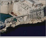
The moat (Menqa in Maltese)
has the shape of a parallelepiped, 70m long between the outside
sea-bridge and its far edge on the Kalkara side, 20m wide
at its narrowest point and 40m at its rear. The current iron
bridge on the Dockyard Creek side of the moat is of modern
construction, and replaced a single-arch stone bridge constructed
about 1901-1904, which had been found to be too low to allow
the passage of boats. This was at the time when the British
Admiralty as a public landing place gave over the camber and
its wharf on the Birgu side to the Civil Government. The high
foot-bridge or passage on the Kalkara side, and the wall at
the back of its two piers is also of modern construction,
having been erected at the turn of the 20th century to serve
as a viaduct for a new sewerage system of the Fort, which
previously was made to flow into the harbour waters. There
was also a proposal at the same time to construct a flight
of steps to go up along the bastion wall of St Angelo to meet
the foot-passage in order to provide an access to Birgu. This
suggestion, however, never materialised.
|
|
The average depth water in the Boat Camber, according to soundings taken by the Navy Works Department of the Admiralty in November 1959, is 2.7m.
In 1979, a stone bridge of disproportionate dimensions was constructed across the boat camber in order to provide access to new accommodation constructed within the Fort. The bridge towered above the wet ditch, which, as already stated is unique in Malta's old fortifications, and was made to abut insensitively on the hallowed walls of St Angelo. Its sheer mass, huge proportions and the unnecessarily wide roadway above it completely marred the historic and aesthetic value of the ditch itself and of the external ramparts of the Fort.
Architect Michael Ellul
|